Navigation
Plan your routes with the help of OpenSeaMap.
Navigation
Two Views
The navigation section has two views: Navigate and edit. You switch between these views using the go! / edit symbol in the action bar, the menu - entry in the popup - menu (see below) or by double tapping at the map.
Edit view
In the edit view you plan your routes.
Create waypoints by tapping on the map. The app adds it to the route. If you tap next to the route a new waypoint is inserted between the waypoints next to it, otherwise appended to the end of the roude.
You move a waypoint by pointing at it and drag it to it's new location. The route is changed accordingly.
Delete a waypoint by tapping on it. Routes are saved automatically at your device.
After you created your route you can start driving it by hiting the go ! button in the toolbar.
Rename Routes
Long tap the the route name to rename the route.
Route Menu
Long tap at the map to open a menu where you choose things to do with the map.
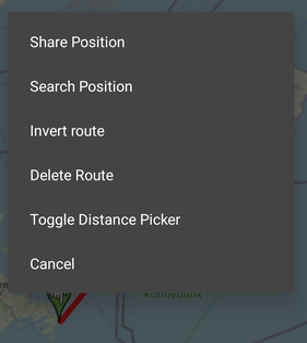
Share Position: Share the location you tap on to your phones share dialog or open the tapped location to Google Maps.
Search Position: Search for towns and regions by name, thanks to the Nominatim search service by open street map (c). Just enter a word and boatspeed tries to find a location for it. The service only works when you're online.
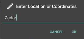
It's also possible to enter geocoordinates, with it a bunch of formates are now understood. For example you may simply enter something like 53.1 13.4, but also full formats like 54°22'12" N 007°12'13" E are understood. If a location can be found, the map scrolls to it, but it is not added automatically to your route.
Invert Route: Switch start and end.
Delete: Delete current route. You may also delete a bunch of routes from the "Choose Routes" dialog.
Distance Picker
The icon on the right bottom of the map shows / hides the distance picker to measure distances on
the map.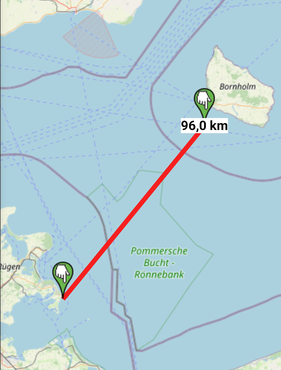
Route Dialog
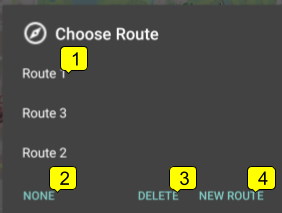 You can open the route-dialog either by clicking at the compass symbol in the action bar or by choosing the "Routes"-entry int the route menu.
(1) Route-Name: Tap at a route name to open it into the main view.
(2) None: Open the main view without any route.
(3) Delete: Open another dialog to delete routes.
(4) New Route: Create a new route.
Route Navigation
When navigating a route we have multifunctional displays showing information on your course in black and on the route in blue:
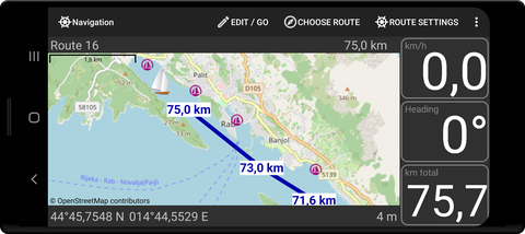
Black displays:
- Your current speed.
- Your course.
- Total remaining distance to aim.
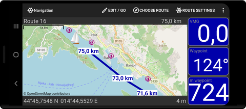
Blue displays:
- Velocity made good along the route.
- Heading to next waypoint.
- Distance to next waypoint.
The displays switch automatically.
The waypoints are visible according to the zoom level. They indicate the distance to the last waypoint.
If you long tap on a waypoint the app switches to the edit mode and you can move the waypoint. Return the the go! - mode by double - tapping or via the popup - menu.
A long tap on the map - not a waypoint - opens the popup - menu.
A double tap on the map makes the map switch to the go! mode and then switch between different zoom levels.
A single short tap zooms the map to different views and makes the map follow your current position.
At the bottom your current location is shown (6). Share it with a long tap.
The number (7) shows the accuracy of your gps in meters. A red background indicates that the accuracy is regarded as not quite good enough for navigation.
Map Download
Map tiles are loaded when displayed and then kept on your device for four weeks. Currently a bulk download of large areas for offline use is not possible due to licence restrictions.
Route Settings
Open the route - settings via the action - bar menu or by long tapping at one of the navigation displays.
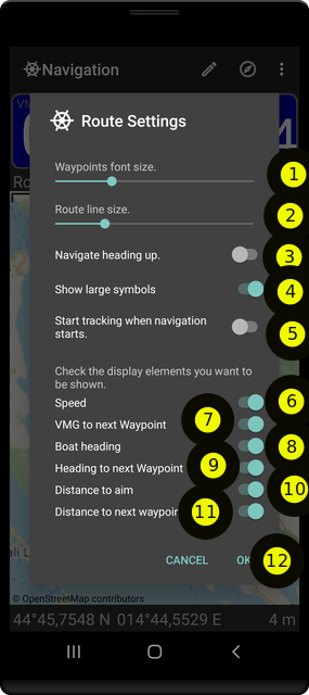
Things to configure:
- (1) Font size of the waypoint labels
- (2) Thickness of the line between the waypoints.
- (3) Navigate heading up, meaning your current course is set top of the map when driving, otherwise north is top.
- (4) Start tracking automatically when you start navigating.
- (5) Show current track on the navigation map if tracking is started.
- (6) Display settings. Switch displays on or off. Black and blue displays switch regularly when activated.
- (Speed) Show current speed display (black).
- (VMG to next Waypoint) Show velocity made good along the route (blue).
- (Boat heading) Show heading display (black).
- (Heading to next waypoint) Show heading to next waypoint (blue).
- (Distance to aim) Total distance to aim (black).
- (Distance to next waypoint) Distance to next waypoint.
Tap ok to confirm your changes (7).
Hint: To change the basic map use the settings dialog.
Importing Routes
Boatspeed now registers for handling gpx tacks and routes, and should be shown as an app for opening these files in the corresponding system-dialog.
The gpx-tracks and routes are shown in the navigation view. For performance reasons the mumber of waypoints to import is limited to 70.
Warning
Please note that this routing is just for planning your tip, but not for navigation. When you go with your boat you have to consult your official natical maps as required by law in many countries.