Tracking Map
Your voyage history
Tracking Map
The tracking-map shows the recorded tracks. It uses OpenSeaMap. You may choose between different base maps in the settings dialog, for additional maps have a look at the shop.
Currently the following data is stored: Time, position latitude and longitude, speed, bearing. The distance value of a waypoints in track is calculated when showing.
The main view shows your tracking data of one or several days. The selected days are shown as title in the top.
At the bottom you can move to your next / previous track or use the buttons on both sides the field. Long tap moves by ten tracks. Between these buttons some statistical information of your track is given, as start time, end time, time spent, top speed (speed), and average speed (avg). You may enlarge this field to see the full information. In the enlarged view there is also a share button to share the tracks stats.
The track shows some labels for waypoints provided by a location service when online. These labels are stored with the track, you may edit them by tapping at them.
Main Menu
Date Select
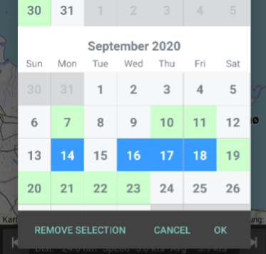 The first icon leads to the date select. This dialog lets you choose one or more
dates to be shown. The gray ones can't be selected because there is no data.
The blue ones are choosen. Notice the REMOVE SELECTION Button to clear your
selection.
The first icon leads to the date select. This dialog lets you choose one or more
dates to be shown. The gray ones can't be selected because there is no data.
The blue ones are choosen. Notice the REMOVE SELECTION Button to clear your
selection.
View Mode
The second icon is the view switch for the waypoints. There are five view modes that show different markers at the map:
- Symbol shows the waypoints as little circles
- Speed shows the speed as waypoint label.
- Distance indicates the distance
- Time gives the hour of day
- and Label shows your custom labels or comments.
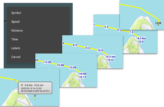
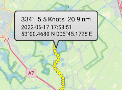
All markers except Labels are only shown when you zoom in. When you tap on a waypoint an infowindow with is shown, giving your course, speed, distance, time and position.
Format and units are shown as configured in the settings dialog.
Other Menu Entries
![]()
The tree dots open the other options:
Import GPX: Import an external gpx track as track to boatspeed. This also imports the special fields of the Navionics Boating App tracks. Since Navionics records a large number of points, the import limits the number of waypoints to one every two minutes.
Export GPX: Export current track as gpx-file.
Export CSV: Export current track as csv-file. Csv-files may be edited for example with Microsoft Excel.
Export as image: Store the current view as png-image.
Share Track Stats: Share the summary of the track.
Delete: Deletes the track. Can't be undone.
Reload: Reloads the track. This will restore any deleted waypoints but cant restore the whole track if deleted.
Backup: Exports all tracks to a zip-file backup.
Restore: Restores a backup.
Follows the general menu entries which are explained in the overview.
Info Window Options
When you tap at a waypoint in the symbol view an infowindow opens with details of the waypoint. When you tap on the infowindow bubble another menu opens that lets you perform actions on that waypoint:
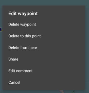
- Delete the waypoint
- Delete all waypoints to this point
- Delete all from this waypoint
- Share opens the share dialog where you also can show this location in Google Maps
- Edit comment. Tap here to enter a comment that is shown in the Label view.
You can also enter comments directly by tapping at a waypoint in the Label view.